
Residents along large parts of Australia’s east coast are being urged to brace for unseasonably dangerous weather today.
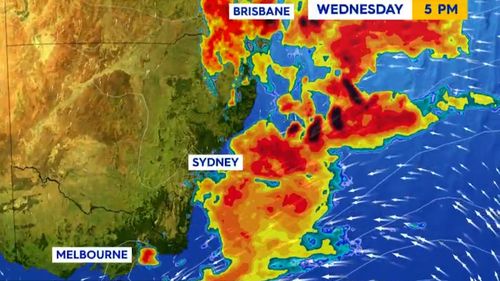
The Bureau of Meteorology (BOM) has warned severe thunderstorms likely to slam north-east New South Wales and south-east Queensland with conditions expected to peak today.
“With those severe thunderstorms, we’re forecasting damaging winds, large hail, heavy rainfall that may lead to flash flooding and there’s already some thunderstorms and showers on the radar at the moment,” Bureau meteorologist Sarah Scully told Today.

The extreme conditions come on top of a wet week for NSW sparking concerns of flash flooding.
“The soil is saturated so any further rainfall that does fall over that area is likely to have increased surface run off and increased likelihood of flash flooding,” Ms Scully said.
Much of the Victorian coast is also in the firing line for severe weather.
Late yesterday, the BOM warned residents from Gippsland in Victoria east to parts of the NSW south coast to brace for heavy rainfall and possible flash flooding.
“Daily rainfall totals of 30mm to 60mm are expected broadly through Gippsland and about the Otways,” the bureau warned.
“Higher totals of 50mm to 100mm are likely across areas east of Orbost as well as the ranges east of Mount Baw Baw, with isolated higher totals possible.
“Heavy rain is expected to continue throughout Tuesday before gradually easing on Tuesday evening and overnight into Wednesday.
“A flood watch is current for catchments in East Gippsland and parts of West Gippsland.”
The warning stretched from roughly Welshpool on the Victorian coast, north past Mount Baw Baw and across to Bega and Eden in NSW. In the west, it included the Otways, from roughly Torquay to Cape Volney.
Ms Scully said mid-May was an “unusual” time of year for severe thunderstorms but high humidity and an upper-level low were driving the unseasonable weather.
“For these really big dynamic thunderstorms, they are usually a summer phenomena … It’s not unprecedented the but it is definitely unusual.”
Weatherzone meteorologist Ben Domensino warned storms could form anywhere from southern NSW to central Queensland.
He said some parts could see even more than 100mm and agreed the worst of the weather could be expected in the afternoon in north-east NSW and south-east Queensland.
“Eastern Australia doesn’t usually brace for a lot of severe thunderstorms in May, but Tuesday will be a dangerous day of weather in multiple states,” he said.
“An upper-level cut-off low-pressure system passing over south-eastern Australia will create an ideal environment for widespread severe weather on Tuesday.
“Moisture-laden air feeding into a surface-based low-pressure system will cause heavy rain in southern and eastern Victoria and far south-east NSW on Monday night and Tuesday.”
Ms Scully predicted the system would continue to cause showers and potentially severe storms in parts of Queensland and NSW tomorrow.
“The peak day for those severe thunderstorms will be today. However, they’re still expecting there to be storms around tomorrow,” she said.
“They will be less widespread and the chances of them being severe is decreased and then they will slowly start to clear and contract out into the Tasman Sea during Thursday.”
The wild weather was already apparent yesterday as strong winds struck Victoria west of the Great Ocean Road and in the Grampians.
Throughout the day, wind gusts reached 111km/h at Mount William, 94km/h at Cape Nelson and 80km/h at Port Fairy.
In Queensland, a severe thunderstorm rolled in from the Lockyer Valley towards Brisbane, Logan and the Gold Coast shortly after midnight.
This content first appear on 9news