Residents from Perth all the way up to Onslow in the Pilbara are facing destructive winds of up to 150 kilometres, intense rainfall and the risk of flash flooding.
First to be impacted will be the area around Exmouth, when Tropical low 23U hits on Saturday night, bringing a brief but intense period of heavy rain and strong to gale-force winds with the possibility of flash flooding.
Some regions could see a month’s worth of rain in a single day.
The low is predicted to intensify into a Category 1 cyclone later today or early tomorrow, when it would be named Tropical Cyclone Odette.
It will bring with it destructive winds, with gusts of up to 150km/h, heavy rains and flash floods.

The Bureau of Meteorology is warning that dangerous surf and a large storm surge will make conditions on the oceans treacherous.
“Tropical Cyclone Seroja has already brought widespread devastation and deaths to parts of Timor Leste state and Indonesia,” Bureau of Meteorology meteorologist Jonathan How said.
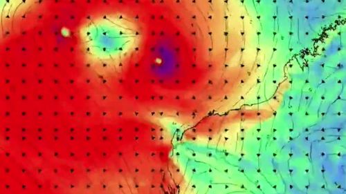
“Over the coming days, both Seroju and 23U will strengthen and dumbbell around each other. This is known as the Fujiwhara effect and isn’t often seen.”
The rarity of the event – last seen in Western Australia in the 1950s – is making the storms’ paths difficult for meteorologists to predict, but it’s expected that Cyclone Seroju will build in strength as it profits off the smaller low.
This content first appear on 9news

