
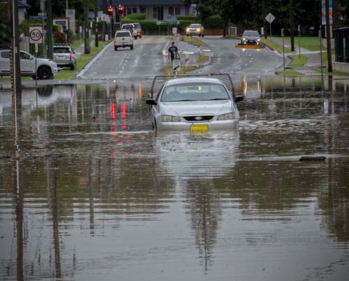
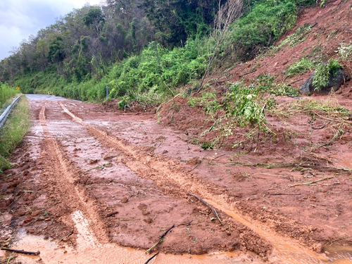
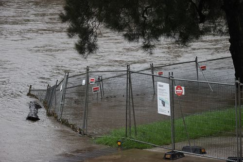
Relentless rainfall across the state has continued overnight and into Sunday morning, prompting new evacuation orders, wide sweeping road closures and landslides.
The Mid North Coast continues to face the brunt of the wet weather while Sydney residents have also copped another heavy battering overnight.
Authorities are warning residents in badly affected regions to avoid floodwaters at all costs and be prepared to evacuate if the SES deem it necessary. People around the state are still encouraged to stay indoors where possible.
:contrast(25)/https%3A%2F%2Fprod.static9.net.au%2Ffs%2Fcb626413-a3fb-4197-995c-5b5269670606)
Dozens of roads up and down the coast have been closed due to flooding, stranding many residents at their homes.
In the state’s north, the Pacific Highway is closed between Coopernook and Glenthorne, while in the south, the Illawarra Highway is closed in both directions through Macquarie Pass. Motorists who do need to drive should exercise extreme caution and allow plenty of extra travel time.

:contrast(19):saturation(1.26)/https%3A%2F%2Fprod.static9.net.au%2Ffs%2F832e92cf-146b-47ee-b00c-a3451566fb5d)
Full list of road closures
• The Pacific Highway is closed between Coopernook and Glenthorne.
• The Oxley Highway is closed between Henry Street at Long Flat and Billabong Drive in Sancrox due to flooding. The highway is also closed between Walcha and Mount Seaview due to a landslide.
• Waterfall Way is closed between Dorrigo Mountain and Thora due to a landslide in Thora.
• At Krambah, Bucketts Way is closed due to a landslide.
• At Corindi Beach, Solitary Islands Way is closed between Blackadder Road and Coral Street.
• At Failford, Failford Road is closed between Mill Road and The Lakes Way.
• Giinagay Way is closed between Warrell Creek and Nambucca Heads.
• At Telegraph Point, Telegraph Point Road is closed between Pacific Highway and Hacks Ferry Road.
• Various roads around the Maitland and Cessnock areas are closed.

• At Cattai, Wisemans Ferry Road is closed across the Cattai Creek bridge.
• Wakehurst Parkway is closed from North Narrabeen to Oxford Falls.
• Oxford Falls Road is closed between Wakehurst Parkway and Arrona Road at Oxford Falls.
• At Pitt Town, Pitt Town Road is closed between Saunders Road and Glebe Road.
• At Windsor, Macquarie Street is closed between Brabyn Street and Bell Street.
• At Riverstone, Garfield Road West is closed between West Parade and Carnarvon Road.
• At Richmond, Bells Line of Road is closed across the Hawkesbury River bridge.
• At Yarramundi, Springwood Road is closed across the Yarramundi bridge.
• At Penrith, The Northern Road is closed between Coreen Avenue and Glebe Place.
• At Penrith, Castlereagh Road is closed between Thornton Drive and Jane Street.
• Jenolan Caves Road is closed in both directions between Duckmaloi Road and Hampton Road at Hampton.

• The Illawarra Highway is closed in both directions through Macquarie Pass. The highway is also closed at Albion Park Rail between Tongarra Road and Croome Lane.
• At the Royal National Park, Audley Rd is closed across the Audley Weir.
This content first appear on 9news