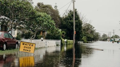
The NSW Rural Fire Service helicopter has captured dramatic imagery of Sydney’s north-west appearing to be like an inland sea.
The footage, which covers the general vicinity of Windsor and Richmond, shows entire blocks and paddocks underwater as the Hawkesbury River bursts its banks due to extreme rainfall.
In one shot, an entire earthmover is underwater, its orange light still flashing as water rushes over the cabin.
The Windsor bridge, which was built just last year, went underwater late yesterday after having been closed to traffic for hours.
NSW’s State Emergency Service has confirmed that major flooding of the Hawkesbury River – particularly at the nearby suburb of North Richmond – is likely to be higher than the historic 1961 flooding event.
“The Hawkesbury River at North Richmond (WPS) is currently at 13.16 metres and falling with major flooding. Renewed rises are possible with forecast rainfall,” the Bureau of Meteorology advised.

“The Hawkesbury River at Windsor (WPS) may peak near 13.00 metres Monday evening with major flooding. This level is similar to the April 1988 and July 1990 flood events.”
A severe weather warning remains for much of NSW’s coast, with damaging winds, heavy rainfall, abnormally high tides and damaging surf forecast.
“A strong high pressure system over the southern Tasman Sea continues to drive widespread and persistent rain onto the New South Wales coast. This is expected to continue today, particularly about the Mid North Coast and Northern Rivers,” the Bureau advises.

“Meanwhile, a low pressure trough in the state’s west is deepening, bringing rain areas to the northern inland today. In this area, heavy rain is possible from the morning, becoming more likely in the afternoon and evening, extending to areas of the southeast over Tuesday.
“On Tuesday, as the trough reaches the Tasman Sea, a low pressure system may form, bringing increased rainfall, strong winds, damaging surf and abnormally high tides to the east and south.”
The entire state is unlikely to experience a reprieve from the wet weather until late Wednesday.
This content first appear on 9news

