
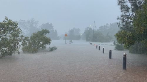
Dozens of NSW Mid North Coast residents have spent the night trapped by rising water from potentially record-breaking flooding as authorities prepare for the big wet to threaten Sydney on Saturday.
After dumping hundreds of millimetres of rain along the coast, forecasters are expecting more of the same as the wild weather crawls south, dumping intense rain and sparking “possible life-threatening flooding”.

Residents in low-lying parts of several towns from Kempsey south to Buhladelah were ordered to evacuate on Friday night but some could not get out.
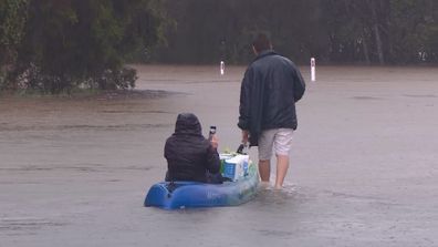
Locals in boats helped ferry people to safety in Telegraph Point but many in the Port Macquarie region were told there simply wouldn’t be enough resources to evacuate them on Friday night.
Statewide, State Emergency Service volunteers had been called to more than 120 flood rescues by 3am on Saturday and close to 400 other jobs. The service had received 2700 calls for help since 7am on Thursday.
Spokesman Dave Webber said many of the flood rescue jobs were still active and more were expected as rain continues to fall.
“There are multiple rivers from minor, right through to major flood warnings on them. We’re probably expecting that we will see flood-of-records in a lot of locations in these places,” he told 9News.com.au.
“So it’s actually been quite dangerous and significant flooding in those areas.”
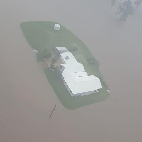
The wider Port Macquarie region appeared to be one of the worst hit, amid evacuation orders and reports of houses inundated and cars swept away by flooding.
Jordan Potts, from nearby Telegraph Point, said the river broke its banks on Friday afternoon and flooded more than half a dozen houses, the primary school, pre-school, a service station and a hair salon.
The 22-year-old apprentice hairdresser said several locals took to their boats to rescue about 10 people and a few pets.
“There were old couples trapped in their homes and thankfully the boys got them out in time,” he told 9News.com.au.
“The water rose rapidly and no-one has ever seen anything like it!
“There were cows stranded on the main road with water up to their necks and [they] were getting swept away.
“People have lost all their belongings. Their houses are unliveable.”
A photo shared to Facebook of torrents of water rushing through a beloved cafe in nearby Kendall prompted an outpouring of sorrow.
Emergency services pleaded with residents right across NSW to stay glued to emergency warnings and heed them, particularly evacuation orders, as quickly as possible.
Some of the orders issued on Friday night left only a few hours for people to make their escape.
“The emergency services don’t have the resources to get to people who stay behind and then are trapped in floodwater,” SES unit commander Michael Ward warned on Triple M Coffs Coast.
‘Dangerous’ weather puts parts of NSW underwater
Affinity Aviation owner Justin Mulcahy was swamped by requests as soon as he put an offer on Facebook to help with evacuations.
In the end, weather conditions were too severe for him to land but the Port Macquarie resident said he passed on some critical information to authorities and would have the helicopter up to assist with evacuations from first light on Saturday.
“It is quite severe or dire, to be honest,” he told 9News.com.au.
“There is a lot of fast-moving water and (it’s) very widespread.
“And I think it has taken a lot of the agencies by surprise.
“And there is a very, very large amount of water, and it’s still raining. So there’s a lot more water to come.”
Mr Webber said agencies like the SES hadn’t been taken by surprise but the wet catchment areas and heavy rainfall presented challenging conditions.
The latest severe weather warning, issued shortly after 2am, stretches from just east of Kempsey on the Mid North Coast, through the Hunter and Sydney metro area past Moruya Heads on the South Coast and west beyond Canberra.
The Bureau of Meteorology forecasts the worst of the heavy rain will hit the Hunter in the early hours of Saturday morning before continuing further south throughout the day.
“In these areas, there may be periods of intense rainfall, potentially leading to life-threatening flash flooding,” the warning stated.
“Roads are likely to be cut off by water, and there will be an increased risk of landslips over this period.”

Senior forecaster Peter Otto said general falls of 150 to 200 millimetres were likely with isolated falls up to 400 millimetres possible.
“This is like Queensland sort of rain. It’s really quite significant,” he told 9News.com.au.
Mr Otto said the low-pressure system driving the rainfall would be at its peak on Saturday, particularly for the Sydney area, which was yet to experience the worst of the weather.
The risk of damaging 60–70km/h winds and gusts exceeding 90km/h would also be significant because of the potential for trees to be knocked down, he said.
This content first appear on 9news