
Severe thunderstorms have dumped heavy rain over parts of eastern NSW this morning with more rain and storms on the way later today.
Strong onshore winds feeding into a low pressure trough caused early-morning storms between the Hunter and Northern Rivers districts of NSW, delivering more than 50mm of rain in just two hours.
The town of Dungog reocrded 52mm as of 7.15am, while one-hour rain rates of 40-50mm were recorded at a couple of gauges in the state’s far northeast.
As of 9am AEDT, a severe thunderstorm warning was in place for small areas in the Hunter and lower Mid North Coast and the upper Northern Rivers.
Showers and storms are likely to become more widespread over northeastern and central NSW as the day progresses, both along the coast and on and west of the ranges.
Some of today’s storms are likely to be severe, with heavy rain the main threat due to copious moisture in the atmosphere.
Elsewhere, troughs in the northern tropics, Western Australia and South Australia are generating rain, showers and storms, while drawing heat south.
An upper feature is causing a few showers in central Queensland.
Onshore winds are bringing showers and the odd storm to eastern parts of New South Wales and Queensland.
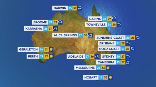
Canberra will be mostly sunny with a top of 27, while Hobart will be hot with a slight chance of a shower later this afternoon.
– Reported with Weatherzone
This content first appear on 9news